User login

What is OpenID?
  • Log in using OpenID
  • Cancel OpenID login
  • Create new account
  • Request new password
Register
  • Home
  • Browse
    • 2D Art
    • 3D Art
    • Concept Art
    • Textures
    • Music
    • Sound Effects
    • Documents
    • Featured Tutorials
  • Submit Art
  • Collect
    • My Collections
    • Art Collections
  • Forums
  • FAQ
  • Leaderboards
    • All Time
      • Total Points
      • Comments
      • Favorites (All)
      • Favorites (2D)
      • Favorites (3D)
      • Favorites (Concept Art)
      • Favorites (Music)
      • Favorites (Sound)
      • Favorites (Textures)
    • Weekly
      • Total Points
      • Comments
      • Favorites (All)
      • Favorites (2D)
      • Favorites (3D)
      • Favorites (Concept Art)
      • Favorites (Music)
      • Favorites (Sound)
      • Favorites (Textures)

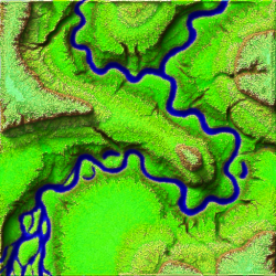
512 by 512 terrain elevation map with layers.

Author: 
Blindman67
Tuesday, January 17, 2017 - 07:00
Art Type: 
3D Art
Tags: 
heightmap
License(s): 
CC-BY 3.0
Collections: 
  • City Simulation
Share Icons: 
Preview: 
Preview

A simple experimental auto generated terain map 512 by 512 pixels. Contains a gray scale height map and a custom height map that extends the dynamic range from 0-255 to 0-765.

All layers were computed from the stacked elevation map. (stacked means Red, Green< Blue channels are stacked (added) to give an elevation)

Also includes is a normal map, occlution map, shadow map, river mask, and colour map. Combined.png is occlution, shadow, colour, and river mask images combined.

The GreyScaleElevation.png is compatable with most terain editors I have tried it on.


File(s): 
RiverTerrainMap.zip RiverTerrainMap.zip 3.9 Mb [125 download(s)]
  • Log in or register to post comments